Recibir este contenido
Argentina. Bariloche
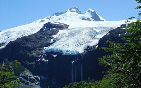
Se encuentra en la zona sur de la cordillera de los Andes, en la frontera entre Argentina y Chile. Separa dos parques nacionales: el Nahuel Huapi, en las provincias de Río Negro y Neuquén (Argentina) y el Vicente Pérez Rosales en la provincia de Llanquihue (Chile). El nombre del cerro se debe al ruido que se produce por los frecuentes desprendimientos de hielo en los glaciares, similar al de los truenos. Su altura es de 3554 m.s.n.m. y posee un total de siete glaciares, siendo el cerro más alto en los alrededores de Bariloche. Tras salir del centro de la ciudad, la mítica ruta Nacional 40 nos lleva hacia el sur, recorriendo las costas de los Lagos Gutiérrez y Mascardi hasta empalmar con la ruta Provincial 82. En el camino encontramos miradores para disfrutar de las imponentes vistas que ofrecen los cerros Bonete y Cresta de Gallo o bien podemos acercarnos a alguna de las playas de arena oscura del lago Mascardi. Nos dirigimos luego a través de bosques autóctonos hasta el río Manso y a partir de aquí un sinuoso camino asciende hasta alcanzar el punto de máxima altura de todo el recorrido. Desde aquí se emprende camino hasta la base del cerro y luego llegamos al último mirador del recorrido: el Ventisquero Negro, un glaciar que desciende desde el Tronador y que se destaca por su color oscuro. Luego emprendemos el camino de regreso a Bariloche.